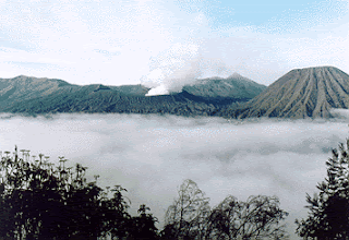
Mount Bromo, situated in Tengger. It is a vast mountain, an eruption of massive proportions blew off its top leaving a huge caldera in which two peaks are located. One is the active volcano of Bromo and the other is the non-active of Mount Batok.
The uniqueness of the area's characteristic is a reminiscent of a moonscape rather than anything related to the earth offers such breathtaking experiences, like observing sunrises and gazing into the volcano's crater
Mt. Bromo is about 2,382 meters above sea level. Time has filled the caldera with grey sand and this expanse, which you walk across en route to Bromo itself, is known as the Sand Sea. It is about 10 km.
Across the Sand Sea is Mount Batok with its almost perfect cone. To the south, Mount Semeru, the highest mountain in Java provides a fining backdrop for this unearthly scene. While crossing the Sand Sea, low-lying fog which often envelops the caldera's floor, adds to the mystery of the surroundings. As the temperature drops several degrees, the combination of cold air and the strange echoing of horse's hoofs creates a fantastic sensation of walking across a huge frozen lake. Temperatures at the top of Mt. Bromo range about 5 to 18 degrees Celsius.
In the south, there is a rolling upland plateau dissected by valleys and dotted with several small scenic lakes extending to the foot of Mt. Semeru, a towering grey forest-skirted cone dominating the southern landscape. The offering ceremony of Kasodo is held each year by Tenggerese on the 14th day of full moon Kesodo (Tenggerese Calendar). Inhabitants of Tengger Mountain gather at the rim of Mt. Bromo's active crater to present annual offerings of rice, fruits, vegetables, flowers, livestock, and other local products to the God of the mountain. As adherents of religion combining elements of Hinduism and Mahayana Buddhism, they ask for blessing from the supreme God Hyang Widi Wasa.
Tourists are driven to the small town of Ngadisari, about six km north-east of Bromo. It is the base camp of the expedition. Necessities for the trip include a torch, warm clothing and some alcoholic drinks as a protection against the freezing temperature which hovers between zero to five degrees Celsius (33 to 41 degrees Fahrenheit). From Ngadisari, the ascent to the crater takes about two hours on foot. On horse-back (ponies can be hired) the excursion takes about an hour and a half. Excursions normally start around midnight.
Ngadisari also has hotel facilities. This enables trippers to stay the night and get up somewhat later than midnight for the trek to Bromo. The last stage of the trip is the flight of steps leading to the rim of Bromo's crater, and, finally, the incomparable view of the rising in the east.
Mount Bromo are located from 145 km south of Surabaya.
How to reach Mount Bromo
==================================================
Surabaya - Probolinggo [90 km] :by bus/ train
Probolinggo - Ngadisari [25 km] :by minibus
Ngadisari - Cemorolawang - Mt. Bromo Crater [3 km] :on foot, on horse back, or by ==================================================
Surabaya - Pasuruan [60 km] :by bus
Pasuruan - Tosari [41 km] :by minibus
Tosari - Wonokitri/ Penanjakan [3 km] :by minibus, it would be better
:by car with 4 wheels drive
Wonokitri - Mt. Bromo Crater [11 km] :on foot
==================================================
Surabaya - Pasuruan [60 km] :by bus
Pasuruan - Purwodadi [29 Km] :by minibus
Purwodadi - Nongkojajar [18 km] :by minibus
Nongkojajar - Mt. Bromo Crater [21 km] :by minibus
How to Reach Mount Bromo
4/
5
Oleh
Unknown


